

DJI Matrice 400 Worry-Free Plus Combo
SKU: CP.EN.00000685.01 Material Code: DJIEMAT400CBUK Brand: DJI
Includes VAT · pay in 3 from £3,550.00 with Klarna
- Extended Flight Time, Dust & Water Resistant
- Upgraded Payload Capacity and Multi-Payload Support
- Power-line-Level Obstacle Sensing, Safer Flight
- Enhanced Intelligence and Efficiency
- Easier Automated Operations
- Comprehensive Accessory Upgrades
- Includes 1 year of DJI Care Enterprise Plus
Free Next Working Day Delivery
Order within 02 hrs 30 mins for delivery by Monday, 12th October (UK Mainland)
Free collection from our Chichester Experience Centre
Included with the DJI Matrice 400 Worry-Free Plus Combo
Over £910.00 worth of extras included!
-
 GVC Course Training (E-Learning)
RRP £499.00
GVC Course Training (E-Learning)
RRP £499.00
-
 Drone Safe Register Professional - 1 Year
RRP £238.79
Drone Safe Register Professional - 1 Year
RRP £238.79
-
 RTK Network Subscription Unlimited 30 Days
RRP £180.00
RTK Network Subscription Unlimited 30 Days
RRP £180.00

Pay Safely & Securely With


What's in the box

DJI Matrice 400

BS100 Intelligent Battery Station

TB100 Intelligent Flight Battery

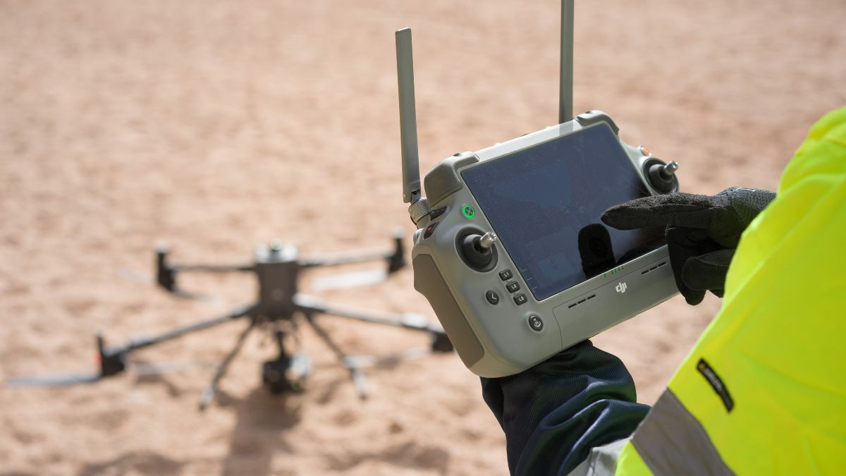
DJI RC Plus 2 Enterprise Enhanced
VIP Membership
Join the club & save £££ - Thousands saved over the years!
DJI Matrice 400 Worry-Free Plus Combo
Flagship enterprise inspection drone, carrying up to 7 payloads
Extended Flight Time
Matrice 400 has a forward flight time of up to 59 minutes, a hover time of up to 53 minutes, and an IP55 protection rating.
Upgraded Payload Capacity
Depending on the task, Matrice 400 can be equipped with the Zenmuse H30 Series, L2, P1, S1 Spotlight, Manifold 3, or third-party payloads.
Built for Continuous, Demanding Operations
- Fly up to 59 minutes on a single battery, or hover for up to 53 minutes, extending mission time between landings.
- Mount up to 7 payloads simultaneously across four E-Port V2 connectors, with a maximum combined payload of 6kg.
- Detect power lines at range using rotating LiDAR and mmWave radar together, useful for corridor inspection in low light or mountainous terrain.
- Operate in genuinely poor conditions with an IP55 rating and a -20°C to 50°C operating range.
- Take off and land on moving platforms, with ship-deck landing pattern recognition for maritime and offshore work.
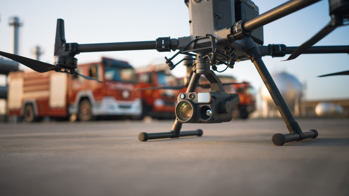
Choose a Payload
The Matrice 400 is a platform first, camera second, built to be configured around the mission rather than fixed to one sensor:
- DJI Zenmuse H30 Series - wide, zoom, and thermal cameras with a laser rangefinder and NIR auxiliary light, for day and night multi-sensor work.
- DJI Zenmuse L3 - high-precision LiDAR for long-range surveying and mapping.
- DJI Zenmuse P1 - full-frame photogrammetry camera for high-accuracy aerial mapping.
- DJI Zenmuse S1 Spotlight - high-brightness illumination for search, rescue, and night inspection.
- DJI Zenmuse V1 Speaker - broadcasts audio instructions and alerts during an operation.
Dual and third gimbal connectors let you run more than one payload at once, for missions that need both a camera and a sensor working together rather than swapping between flights.
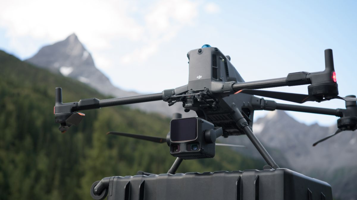
Power-Line-Level Obstacle Sensing
Rotating LiDAR, mmWave radar, and full-colour low-light fisheye vision sensors work together to detect power lines across mountainous terrain, even in darkness. The mmWave radar alone detects wire down to 12.5mm from up to 36m out, extending to 50m for larger 21.6mm cable.
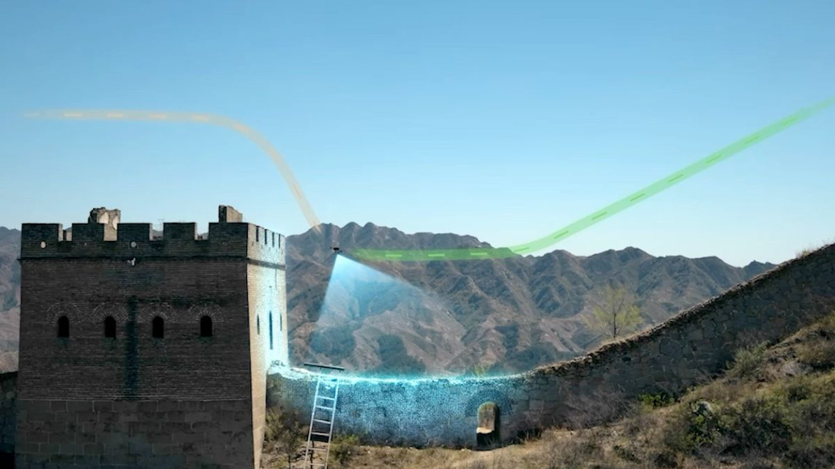
Enhanced Intelligence and Automation
Smart Detection identifies obstacles and points of interest automatically, while Smart AR Projection overlays maps, power lines, and return paths directly onto the controller view. Real-time terrain following adjusts altitude automatically over changing ground, and automated power line inspection flights run directly with the Zenmuse L2 payload, with slope and geometric route planning available through DJI FlightHub 2.
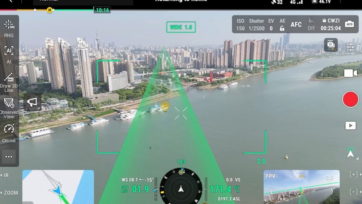
O4 Enterprise Enhanced transmission reaches up to 40km unobstructed under FCC standards (20km under CE/SRRC/MIC), with support for dual control mode and 2-channel Cellular Dongle 2 for added signal stability. Live view runs across 3 channels at 1080p/30fps simultaneously, useful when multiple team members need eyes on different feeds during one mission.
Specification
| Specification | Value |
|---|---|
| Aircraft | |
| Takeoff Weight (with propellers) | Without Batteries: 5020±20 g With Batteries: 9740±40 g The actual product weight may vary due to differences in batch materials and external factors. |
| Max Takeoff Weight | 15.8 kg |
| Dimensions | Unfolded: 980×760×480 mm (L×W×H) (with landing gear) Folded: 490×490×480 mm (L×W×H) (with landing gear and gimbal) Aircraft carrying case: 779×363×528 mm (L×W×H) Maximum dimensions excluding propellers. |
| Max Payload | 6 kg Measured at the third gimbal connector under sea level conditions. Payload capacity decreases as altitude increases. Refer to user manual. |
| Propeller Size | 25 inches |
| Diagonal Wheelbase | 1070 mm |
| Max Ascent Speed | 10 m/s |
| Max Descent Speed | 8 m/s |
| Max Horizontal Speed | 25 m/s (at sea level, no wind) |
| Max Takeoff Altitude | 7000 m |
| Max Flight Time (no wind) | 59 minutes Measured with H30T only, flying at 10 m/s at sea level from 100% to 0% battery. For reference only. |
| Max Hover Time (no wind) | 53 minutes Measured with H30T only, hovering from 100% to 0% battery. For reference only. |
| Max Flight Distance (no wind) | 49 km Measured at 17 m/s with no payload at sea level. For reference only. |
| Max Wind Speed Resistance | 12 m/s (during takeoff and landing) |
| Max Yaw Angular Velocity | Yaw: 100°/s |
| Max Pitch Angle | 35° |
| Operating Temperature | -20° to 50° C (-4° to 122° F) (without solar radiation) |
| Global Navigation Satellite System (GNSS) | GPS + Galileo + BeiDou + GLONASS* * GLONASS is supported only when RTK is enabled. Includes ADS-B In with dual antennas, supports reception up to 20 km. |
| Hovering Accuracy Range | Vertical: ±0.1 m (with vision positioning) ±0.5 m (with satellite positioning) ±0.1 m (with RTK positioning) Horizontal: ±0.3 m (with vision positioning) ±0.5 m (with satellite positioning) ±0.1 m (with RTK positioning) |
| RTK GNSS Accuracy | RTK Fix: 1 cm + 1 ppm (horizontal), 1.5 cm + 1 ppm (vertical) |
| RTK Heading | Supports heading with accuracy better than 2° |
| Airborne ADS-B In | Equipped, supports reception up to 20 km |
| Internal Storage | N/A |
| Ports | USB-C Debug Port × 1: USB 2.0 E-Port V2 × 4: Lower drone body, 120W each Cellular Dongle 2 Interface × 2: Underside of drone |
| Propeller Model | 2510F |
| Beacon | Built into the aircraft |
| Ingress Protection Rating | IP55 Rating may degrade due to product wear and tear. |
| Gimbal | |
| Maximum Payload for Single Gimbal Connector | 1400 g If exceeded, gimbal damper lifespan decreases from 1000 hours to 400 hours. |
| Maximum Payload for Dual Gimbal Connector | 950 g |
| Maximum Payload for Third Gimbal Connector | 3 kg (quick-release port), 6 kg (screw lock fastening) |
| Sensing | |
| Sensing Type | Omnidirectional binocular vision system (surround view provided by full-color fisheye vision sensors) Horizontal rotating LiDAR, upper LiDAR and downward 3D infrared range sensor Six-direction mmWave radar |
| Forward | Measurement Range: 0.4-21 m Detection Range: 0.4-200 m FOV: 90° (horizontal), 90° (vertical) |
| Backward | Measurement Range: 0.4-21 m Detection Range: 0.4-200 m FOV: 90° (horizontal), 90° (vertical) |
| Lateral | Measurement Range: 0.6-21 m Detection Range: 0.5-200 m FOV: 90° (horizontal), 90° (vertical) |
| Downward | Measurement Range: 0.5-19 m FOV: 160° (front/rear), 105° (left/right) |
| Operating Environment | Forward, Backward, Left, Right, and Upward: Delicate texture on the surface, adequate light. Downward: The ground has rich textures and sufficient lighting conditions*, with a diffuse reflection surface and a reflectivity greater than 20% (such as walls, trees, people, etc.). * Sufficient lighting conditions refer to an illuminance not lower than that of a nighttime city light scene. |
| Rotating LiDAR | Standard Measurement Range: 0.5-100 m @ 100,000 lux with 10% reflectivity target Power Line Range: 35 m @ 30° @ 10,000 lux for 21.6 mm steel-core aluminum wire FOV: 360° (horizontal), 58° (vertical) Point-Frequency: 520,000 points/s Laser Wavelength: 905 nm Eye Safety: Class 1 (IEC60825-1:2014) |
| Upper LiDAR (3D ToF) | Range: 0.5-25 m at night (reflectivity > 10%) FOV: 60° (up/down), 60° (left/right) |
| Downward 3D Infrared Range Sensor | Range: 0.3-8 m (reflectivity > 10%) FOV: 60° (front/rear), 60° (left/right) |
| mmWave Radar | Power Line Range: – 36 m for 12.5 mm steel-core aluminum wire – 50 m for 21.6 mm steel-core aluminum wire FOV: ±45° (horizontal and vertical) The mmWave radar function is unavailable in some countries/regions. |
| FPV Camera | |
| Resolution | 1080p |
| Field of View (FOV) | DFOV: 150° HFOV: 139.6° VFOV: 95.3° |
| Frame Rate | 30fps |
| Night Vision | Starlight Grade |
| Video Transmission | |
| Video Transmission System | DJI O4 Enterprise Enhanced Video Transmission System |
| Live View Quality | Remote Controller: 3-channel 1080p/30fps |
| Operating Frequency and Transmitter Power (EIRP) | 902-928 MHz: < 30 dBm (FCC), < 16 dBm (MIC) 1.430-1.444 GHz: < 35 dBm (SRRC) 2.4000-2.4835 GHz: < 33 dBm (FCC), < 20 dBm (CE/SRRC/MIC) 5.150-5.250 GHz: < 23 dBm (FCC/CE) 5.725-5.850 GHz: < 33 dBm (FCC), < 14 dBm (CE), < 30 dBm (SRRC) Operating frequency allowed varies among countries and regions. Refer to local laws and regulations for more information. |
| Max Transmission Distance (unobstructed, free of interference) | 40 km (FCC) 20 km (CE/SRRC/MIC) Measured in an unobstructed environment free of interference. The above data shows the farthest communication range for one-way, non-return flights under each standard. During your flight, please pay attention to RTH reminder on the DJI Pilot 2 app. |
| Max Transmission Distance (with interference) | Strong interference: approx. 1.5-6 km Medium interference: approx. 6-15 km Weak interference: approx. 15-40 km Data is tested under FCC standard in unobstructed environments of typical interference. Only to serve as a reference and provides no guarantee as to the actual flight distance. |
| Max Download Speed | Standard Mode: 80 Mbps Downlink Playback Download: < 25 MBps Single-Channel Bitrate: ≤ 12 Mbps The above data was measured under conditions where the aircraft and remote controller were in close proximity without interference. |
| Antenna | WLAN Antenna × 8: 6 vertically polarized antennas and 2 horizontally polarized antennas sub2G Antenna × 2: 2 vertically polarized antennas 4G Antenna × 4 |
| Operating Mode | 2T4R |
| Others | Supports Dual Control Mode and 2-channel Cellular Dongle 2 |
| DJI RC Plus 2 Enterprise Enhanced | |
| Video Transmission System | DJI O4 Enterprise Enhanced Video Transmission System |
| Max Transmission Distance (unobstructed, free of interference) | 40 km (FCC) 20 km (CE/SRRC/MIC) Measured in an unobstructed environment free of interference. The above data shows the farthest communication range for one-way, non-return flights under each standard. During your flight, please pay attention to RTH reminder on the DJI Pilot 2 app. |
| Video Transmission Operating Frequency and Transmitter Power (EIRP) | 902-928 MHz: < 30 dBm (FCC), < 16 dBm (MIC) 2.400-2.4835 GHz: < 33 dBm (FCC), < 20 dBm (CE/SRRC/MIC) 5.150-5.250 GHz: < 23 dBm (FCC/CE) 5.725-5.850 GHz: < 33 dBm (FCC), < 14 dBm (CE), < 30 dBm (SRRC) Operating frequency allowed varies among countries and regions. Refer to local laws and regulations for more information. |
| Antenna | 2T4R, 2.4GHz/5.8GHz multi-beam high-gain antenna sub2G Module: 2T2R |
| Enhanced Transmission | Supports DJI Cellular Dongle 2 |
| Wi-Fi Protocol | Wi-Fi Direct, Wireless Display, IEEE 802.11 a/b/n/ac/ax Supports 2×2 MIMO Wi-Fi, dual-band simultaneous (DBS) with dual MAC, data rates up to 1774.5 Mbps |
| Wi-Fi Operating Frequency | 2.4000-2.4835 GHz 5.150-5.250 GHz 5.725-5.850 GHz 5.2 and 5.8GHz frequencies are prohibited in some countries. In some countries, 5.2GHz is only allowed indoors. |
| Wi-Fi Transmitter Power (EIRP) | 2.4 GHz: < 26 dBm, < 20 dBm (CE/SRRC/MIC) 5.1 GHz: < 23 dBm (FCC/CE/SRRC/MIC) 5.8 GHz: < 23 dBm (FCC/SRRC), < 14 dBm (CE) |
| Bluetooth Protocol | Bluetooth 5.2 |
| Bluetooth Operating Frequency | 2.400-2.4835 GHz |
| Bluetooth Transmitter Power (EIRP) | < 10 dBm |
| Screen Resolution | 1920 × 1200 |
| Screen Size | 7.02 inches |
| Screen Frame Rate | 60fps |
| Brightness | 1400 nits |
| Touchscreen Control | 10-Point Multi-Touch |
| Built-in Battery | 2S2P 18650 Lithium-ion, 6500 mAh @ 7.2 V (46.8 Wh) |
| External Battery | Optional, WB37 (4920 mAh @ 7.6 V) 37 Wh |
| Charging Type | Supports PD fast charging (20V/3.25A) via USB Type-C |
| Storage Capacity | RAM 8G + ROM 128G UFS + microSD expandable |
| Charging Time | 2 hrs (internal battery) 2 hrs (internal + external) Measured when powered off using standard DJI charger. |
| Internal Battery Runtime | 3.8 hours |
| External Battery Runtime | 3.2 hours |
| Output Port | HDMI 1.4 |
| Indicators | Status LED, battery level LED, connection status LED, tricolour light, ambient light brightness adjustment |
| Speaker | Supports buzzer |
| Audio | Array MIC |
| Operating Temperature | -20° to 50° C (-4° to 122° F) |
| Storage Temperature | Within one month: -30° to 45° C (-22° to 140° F) One to three months: -30° to 35° C (-22° to 113° F) Three months to one year: -30° to 30° C (-22° to 86° F) |
| Charging Temperature | 5° to 40° C (41° to 104° F) |
| Supported Aircraft Model | Matrice 400 |
| Global Navigation Satellite System | GPS + Galileo + BeiDou |
| Dimensions | 268×163×94.5 mm (L×W×H) Measured with external antenna folded, including handle and sticks. |
| Weight | 1.15 kg (without external battery) |
| Model | TKPL 2 |
| System Version | Android 11 |
| External Interfaces | HDMI 1.4, SD 3.0, USB-C (OTG, PD 65W), USB-A (USB 2.0) |
| Accessories | Strap/waist support |
Choose a Payload
DJI Zenmuse L3 – High-precision LiDAR payload with robust long-range scanning and imaging capabilities for advanced surveying and mapping missions.
DJI Zenmuse H30T Drone Payload – All-weather multi-sensor payload integrating high-resolution wide, zoom, thermal, laser rangefinder and NIR auxiliary light sensors.
DJI Zenmuse P1 Camera Body – Full-frame photogrammetry camera payload ideal for high-accuracy aerial mapping and surveying missions.
DJI Zenmuse H30 – Multi-sensor payload combining wide and zoom cameras with a laser rangefinder and NIR auxiliary light for day/night operations.
DJI Zenmuse S1 (Searchlight) – High-brightness spotlight payload designed for enhanced illumination in search, rescue and inspection missions (available through DJI authorised channels).
DJI Zenmuse V1 (Voice Speaker) – Professional speaker payload for broadcasting audio instructions and alerts during operations (available through DJI authorised channels).
Recommended Accessories
DJI TB100 Intelligent Flight Battery – Genuine high-capacity flight battery for the DJI Matrice 400, powering long-duration missions.
DJI Matrice 400 TB100C Tethered Battery – Tethered power battery option designed for extended continuous flight and tethered operations.
DJI BS100 Intelligent Battery Station – Smart charging hub that supports efficient charging and battery management for TB100 (and compatible batteries).
DJI Matrice 400 Dual Gimbal Connector – Connector accessory that enables the mount of dual gimbals on the Matrice 400 for multi-sensor operations.
DJI Matrice 400 Third Gimbal Connector – Enables adding a third mounted gimbal to further expand payload flexibility.
DJI M400 2510F Propellers – Official replacement or spare propellers for the Matrice 400 series.
Drone Training Courses
What's in the box?
1 x DJI Matrice 400
1 x TB100 Intelligent Flight Battery
1 x BS100 Intelligent Battery Station
1 x DJI RC Plus 2 Enterprise Enhanced
1 x DJI RC Plus 2 sub2G SDR Module
1 x DJI RC Plus 2 Strap and Bracket Kit
1 x DJI Matrice 400 2510F Propeller
1 x DJI Matrice 400 Gimbal Damper
1 x DJI Matrice 400 Carrying Case
1 x Rotating LiDAR Calibration Cover
1 x Front Propeller Holder
1 x Rear Propeller Holder
1 x USB-C to USB-C Data Cable
1 x WB37 Battery
2 x E-Port V2 Rubber Port Cover
4 x Rubber Plug Screws (2×2)
1 x Screws and Tools
1 x Cleaning Tools
What's Included Beyond the Hardware
- 1 Year DJI Care Enterprise Plus, covering accidental damage.
- GVC Course Training (E-Learning) worth £499.00, the qualification most commercial operators of this class of aircraft will need.
- Drone Safe Register Professional (1 Year) worth £238.79.
- RTK Network Subscription (30 Days Unlimited) worth £180.
Frequently Asked Questions
Do I need a payload, or does the Matrice 400 come with one?
This Worry-Free Plus Combo is the aircraft, battery, and controller only. Payloads such as the H30 Series, L2, or P1 are chosen and purchased separately depending on your mission.
How many payloads can I run at once?
Up to 7 simultaneously across four E-Port V2 connectors, with a combined maximum payload of 6kg. Dual and third gimbal connectors are available for multi-sensor configurations.
Is the Matrice 400 waterproof?
It carries an IP55 rating, offering protection against dust and light rain, though this can degrade with wear over time. Avoid flying in heavy rain regardless of rating.
Do I need a licence to fly the Matrice 400 commercially in the UK?
Yes. At this weight, you'll need an Operator ID and a GVC, included in this bundle as an e-learning course. Our team can talk you through the full requirements before you buy.
Can I get this on finance?
Ltd companies can access iwocaPay financing, and individual buyers can use Klarna or Clearpay at checkout.
What warranty comes with this aircraft?
| Component | Warranty |
|---|---|
| DJI Matrice 400 | 24 Months |
| DJI RC Plus 2 Enterprise Enhanced | 24 Months |
| DJI RC Plus 2 sub2G SDR Module | 24 Months |
| BS100 Intelligent Battery Station | 24 Months |
| TB100 Intelligent Flight Battery | 12 months and Charge Cycle less than 400 times |
| TB100C Tethered Battery | 12 months and Charge Cycle less than 400 times |
| WB37 Battery | 12 Months |
| DJI SKYPORT V3 Adapter Set | 24 Months |
| DJI SKYPORT V3 Coaxial Cable Kit | 24 Months |
| Single/Dual/Third Gimbal Connector | 24 Months |
| DJI E-Port V2 Development Kit | 24 Months |
| DJI E-Port V2 Coaxial Cable Kit | 24 Months |
| DJI Cellular Dongle 2 | 24 Months |
| Aircraft Safety Case | 6 Months |
| DJI Matrice 400 2510F Propeller | No Warranty |
| DJI Matrice 400 Gimbal Damper | No Warranty |
| Other Accessories | No Warranty |
Why Buy From Drone Safe Store
Every Matrice 400 ships from UK stock, and our in-house engineers handle servicing and repairs directly. Given the range of payloads available, our team can talk through which configuration fits your operation before you commit to it.
Where to Find Us
Drone Safe Store Showroom
Unit 1K, St James' Industrial Estate, Westhampnett Rd, Chichester PO19 7JU
Opening Hours: Monday to Saturday, 9:00am to 5:30pm
Get In Touch
Have a question about payload configuration, or need a quote for a fleet order? Call us.
What our customers say - 1,776+ Google reviews
"Fabulous , friendly family business. Honest opinions given and no pressure sales"
"My first time purchasing from them, we got the best price on the net and contact with them throughout the delivery and after was fantastic."
"Absolutely go above and beyond what other sellers do. Wouldn't hesitate to recommend them,the peace of mind you have when buying expensive drones and equipment knowing yo..."
Accreditation
 Armed Forces Covenant
Proudly supporting the Armed Forces community and veterans.
Armed Forces Covenant
Proudly supporting the Armed Forces community and veterans.
 ISO 9001 Certified
Certified quality management systems for consistent service and customer satisfaction.
ISO 9001 Certified
Certified quality management systems for consistent service and customer satisfaction.
 DJI Enterprise A Rank Retailer
DJI's highest level of authorised retail and technical expertise.
DJI Enterprise A Rank Retailer
DJI's highest level of authorised retail and technical expertise.
 D-U-N-S® Registered
Globally recognised business identity, verified for international trade. Number: 221162020
D-U-N-S® Registered
Globally recognised business identity, verified for international trade. Number: 221162020
 Financial Conduct Authority
Authorised and regulated by the FCA for consumer finance activities.
Financial Conduct Authority
Authorised and regulated by the FCA for consumer finance activities.
 YPO Approved Supplier
Approved on the YPO framework as a supplier for Drones & Associated Services to help the Public Sector
YPO Approved Supplier
Approved on the YPO framework as a supplier for Drones & Associated Services to help the Public Sector