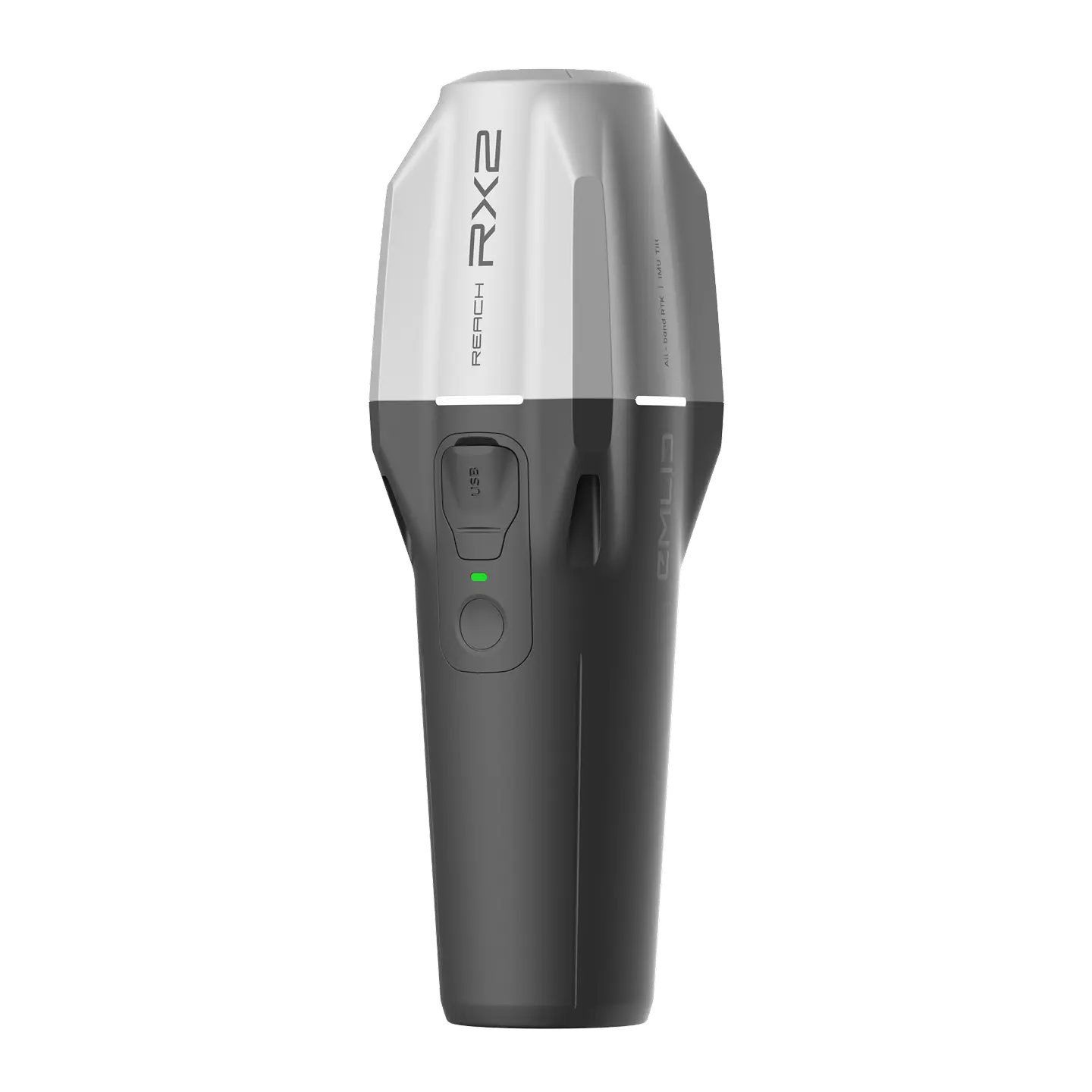
Emlid Reach RX2
Brand: Emlid
Includes VAT · pay in 3 from £699.67 with Klarna
- Compact RTK rover
- Centimetre accuracy on tilt
- Instant setup workflow
- GIS app compatible
Free Next Working Day Delivery
Order within 01 hrs 16 mins for delivery by Tuesday, 4th August (UK Mainland)
Free collection from our Chichester Experience Centre
Included with the Emlid Reach RX2
Over £180.00 worth of extras included!
-
 RTK Network Subscription Unlimited 30 Days
RRP £180.00
RTK Network Subscription Unlimited 30 Days
RRP £180.00

Pay Safely & Securely With


VIP Membership
Join the club & save £££ - Thousands saved over the years!
Emlid Reach RX2 Compact RTK Rover for GIS, Mapping and Layout
The Emlid Reach RX2 is a compact and lightweight RTK rover designed for fast, accurate field data collection. Built for GIS, surveying, mapping, and layout work, RX2 delivers centimetre-level accuracy with built-in tilt compensation, allowing precise measurements even when the pole is not perfectly vertical.
Optimised for mobility and rapid setup, the RX2 is ideal for field crews working in constrained, complex, or fast-moving environments.
Fast and Precise Mapping in Any Landscape
Accurate on the Tilt
The RX2 maintains centimetre accuracy at high tilt angles, making it easy to measure near walls, slopes, and tight spaces without stopping to level the pole.
No Setup Required
Tilt compensation activates automatically after a short walk. There are no calibration steps or setup routines, allowing you to start work immediately.
Quick Release Mount
The purpose-built quick release mount secures the RX2 firmly to the pole with no backlash, ensuring stable and repeatable measurements.
Ready for Data Collection and Design Layout
Every Reach RX2 includes Emlid Flow, a user-friendly mobile and cloud platform available on iOS and Android.
Designed for construction, utilities, GIS, landscaping, and surveying
Real-time field data collection and layout
Automatic cloud synchronisation so office teams always have the latest data
RX2 is built to fit seamlessly into existing workflows.
Compatible with Esri and Leading GIS Apps
With Apple MFi certification, the RX2 connects natively and reliably to iPhones and iPads and works seamlessly with Android devices.
It supports all major GIS and data collection applications, including:
ArcGIS Field Maps
Survey123
QField
Mergin Maps
And many more
This makes RX2 ideal for local authorities, urban planning, utilities, environmental monitoring, and digital twin projects.
Terrestrial Scanning with Centimetre Precision
The Reach RX2 supports high-accuracy terrestrial scanning when paired with compatible apps such as PIX4Dcatch.
Capture detailed 3D models of vertical surfaces
Measure hard-to-reach areas safely
Ideal for utilities mapping, volume calculations, and as-built documentation
Simply mount the RX2 on a handle and scan with confidence.
High Accuracy Even Under Canopy
Centimetre Level RTK Accuracy
Connect to a CORS network to receive RTK corrections and achieve precise positioning in real time.
All Band GNSS Rover
RX2 tracks all major satellite constellations and frequency bands, including GPS, GLONASS, Galileo, BeiDou, QZSS, and NavIC. This ensures fast and stable performance under tree cover and near buildings.
Built to Keep Up in the Field
Compact and Lightweight
Weighing just 280 g, the RX2 easily fits in a pocket, backpack, or glove compartment.
Long Battery Life
Up to 18 hours of operation
USB-C charging for convenience in the field
Weather Resistant
Designed to perform reliably in rain, snow, and direct sunlight.
Scales with Your Team
RX2 is designed for teams of any size. It works straight out of the box and is quick to learn, allowing new users to start collecting accurate data immediately.
With Emlid Flow, teams benefit from:
Real-time field to office collaboration
Progress tracking
Faster issue resolution before problems escalate
No lengthy training sessions or manuals required.
What our customers say - 1,729+ Google reviews
"Very efficient is my impression. I wanted a storage/carry case for my drone and equipment and the guys had the perfect one. I ordered it on the Monday afternoon and recei..."
"Great service , prompt delivery 👌"
"Rapid service, good price and flexible.payment options."
Accreditation
 Armed Forces Covenant
Proudly supporting the Armed Forces community and veterans.
Armed Forces Covenant
Proudly supporting the Armed Forces community and veterans.
 ISO 9001 Certified
Certified quality management systems for consistent service and customer satisfaction.
ISO 9001 Certified
Certified quality management systems for consistent service and customer satisfaction.
 DJI Enterprise A Rank Retailer
DJI's highest level of authorised retail and technical expertise.
DJI Enterprise A Rank Retailer
DJI's highest level of authorised retail and technical expertise.
 D-U-N-S® Registered
Globally recognised business identity, verified for international trade. Number: 221162020
D-U-N-S® Registered
Globally recognised business identity, verified for international trade. Number: 221162020
 Financial Conduct Authority
Authorised and regulated by the FCA for consumer finance activities.
Financial Conduct Authority
Authorised and regulated by the FCA for consumer finance activities.
 YPO Approved Supplier
Approved on the YPO framework as a supplier for Drones & Associated Services to help the Public Sector
YPO Approved Supplier
Approved on the YPO framework as a supplier for Drones & Associated Services to help the Public Sector