
DJI Terra - Flagship - Permanent
SKU: CP.RJ.00000225.01 Brand: DJI
Includes VAT · pay in 3 from £3,103.33 with Klarna
- High Accuracy 3D Mapping
- LiDAR Point Cloud Processing
- Multispectral Vegetation Index Analysis
Free Next Working Day Delivery
Order within 11 hrs 02 mins for delivery by Tuesday, 28th July (UK Mainland)
Free collection from our Chichester Experience Centre

Pay Safely & Securely With
VIP Membership
Join the club & save £££ - Thousands saved over the years!
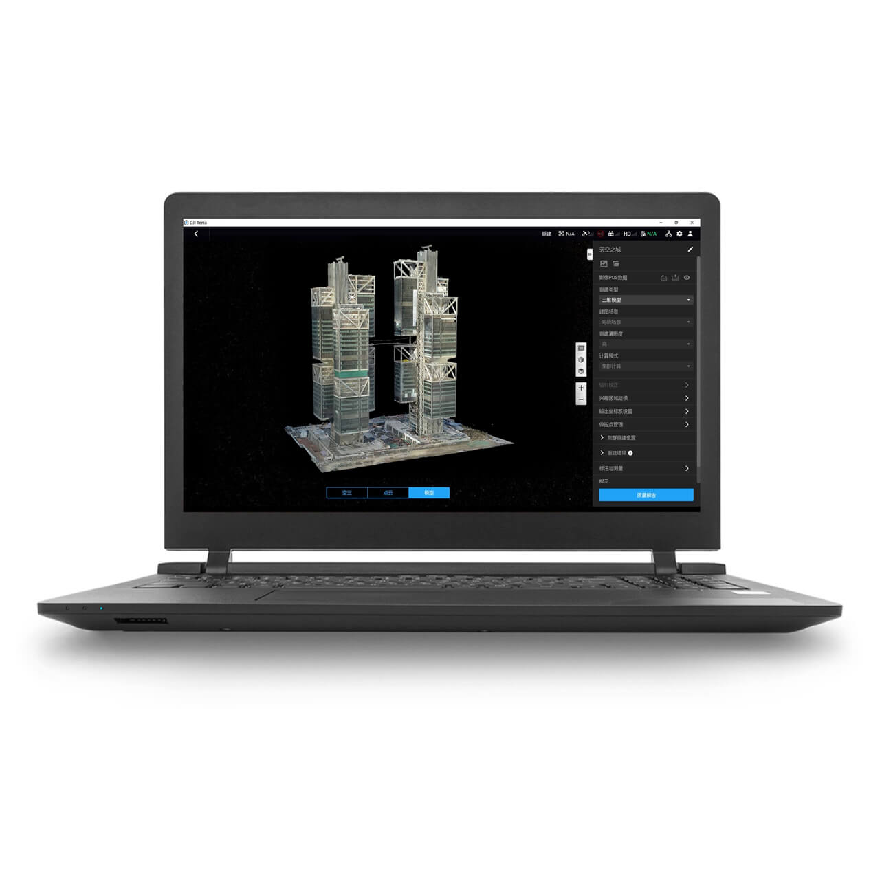
DJI Terra - Professional Drone Mapping & 3D Modelling Software
DJI Terra is DJI’s powerful all-in-one mapping and reconstruction software, designed to help drone pilots and survey teams turn aerial data into highly accurate 2D maps, 3D models, point clouds, and actionable insights.
Built for enterprise workflows, Terra streamlines everything from mission planning and automated data capture through to advanced processing for industries such as surveying, construction, utilities, agriculture, and public safety.
Whether you're producing detailed orthomosaics, processing LiDAR datasets, or creating photorealistic digital twins using Gaussian Splatting, DJI Terra delivers fast, reliable results within the DJI ecosystem.
Key Features
End-to-End Drone Mapping Workflow
Plan flight routes, capture data efficiently, and process outputs in one seamless software platform.
High-Accuracy 2D & 3D Reconstruction
Generate centimetre-accurate orthomosaics, dense point clouds, and realistic 3D meshes from DJI mapping drones.
LiDAR Point Cloud Processing
Fully compatible with Zenmuse L1, L2, and L3 payloads, supporting RTK/PPK workflows and advanced classification for terrain modelling.
Gaussian Splatting for Photorealistic Models
Create stunning, true-to-life 3D models with real-time rendering - ideal for heritage, tourism, construction visualisation, and digital twin applications.
Multispectral Crop & Vegetation Analysis
Produce NDVI and NDRE vegetation index maps using platforms such as Mavic 3 Multispectral for precision agriculture and environmental monitoring.
Massive Scale Capability
Terra supports large-area processing with cluster reconstruction technology, enabling city-scale modelling and high-volume dataset handling.
Flexible Export & Compatibility
Output common formats including TIFF, LAS, OBJ, DXF, SHP, and 3D Tiles for easy integration into GIS, CAD, BIM, and third-party software.
Ideal For
Surveying & Mapping Professionals
Construction Progress & Volumetrics
Utilities & Infrastructure Inspection
Public Safety & Incident Response
Agriculture & Crop Health Monitoring
Cultural Heritage Preservation
Drone-in-a-Box and Remote Operations (Dock 2 compatible)
DJI Terra is available in multiple licence options depending on your operational needs. Choose the version that best fits your workflow, from photogrammetry-only through to full LiDAR and advanced reconstruction suites.
What our customers say - 1,721+ Google reviews
"Perfect in all areas, Staff spend time to explain something in detail in plain speak that enables you to make an informed choice. The Drone was spot on for my son. A win..."
"Great shopping experience with these guys, ordered Sunday, delivered Tuesday. . . With a better deal than the DJI website, £80 off, with a free 128gb SD card & RC2 scree..."
"bought a few items from Drone Safe Store of high value (matrice 4e, various accessories additional batteries, manifold 4 and payload development kit) always arrives promp..."
Accreditation
 Armed Forces Covenant
Proudly supporting the Armed Forces community and veterans.
Armed Forces Covenant
Proudly supporting the Armed Forces community and veterans.
 ISO 9001 Certified
Certified quality management systems for consistent service and customer satisfaction.
ISO 9001 Certified
Certified quality management systems for consistent service and customer satisfaction.
 DJI Enterprise A Rank Retailer
DJI's highest level of authorised retail and technical expertise.
DJI Enterprise A Rank Retailer
DJI's highest level of authorised retail and technical expertise.
 D-U-N-S® Registered
Globally recognised business identity, verified for international trade. Number: 221162020
D-U-N-S® Registered
Globally recognised business identity, verified for international trade. Number: 221162020
 Financial Conduct Authority
Authorised and regulated by the FCA for consumer finance activities.
Financial Conduct Authority
Authorised and regulated by the FCA for consumer finance activities.
 YPO Approved Supplier
Approved on the YPO framework as a supplier for Drones & Associated Services to help the Public Sector
YPO Approved Supplier
Approved on the YPO framework as a supplier for Drones & Associated Services to help the Public Sector